
Mapa topográfico River Dee
Mapa interactivo
Haga clic en el mapa para ver la altitud.
Acerca de este mapa
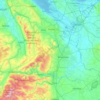
Nombre: Mapa topográfico River Dee, altitud, relieve.
Lugar: River Dee, Wales, United Kingdom (52.90304 -3.59309 53.25333 -2.85768)
Altitud media: 157 m
Altitud mínima: 0 m
Altitud máxima: 821 m
Otros mapas topográficos
Haga clic en un mapa para ver su topografía, su altitud y su relieve.
Snowdon
United Kingdom > Wales > Gwynedd
Snowdon (/ˈsnoʊdən/) or Yr Wyddfa (pronounced [ər ˈʊɨ̞̯ðva] (listen)), is the highest mountain in Wales, at an elevation of 1,085 metres (3,560 ft) above sea level, and the highest point in the British Isles outside the Scottish Highlands. It is located in Snowdonia National Park (Parc Cenedlaethol…
Altitud media: 692 m
Swansea
United Kingdom > Wales > Swansea
Much of Swansea is hilly with the main area of upland being located in the council ward of Mawr. Areas up to 185 metres (607 ft) in elevation range across the central section: Kilvey Hill, Townhill and Llwynmawr separate the centre of Swansea from its northern suburbs. Cefn Bryn, a ridge of high land, is the…
Altitud media: 73 m
Aberystwyth
United Kingdom > Wales > Ceredigion
Aberystwyth experiences an oceanic climate (Köppen climate classification Cfb) similar to almost all of the United Kingdom. This is particularly pronounced due to its west coast location facing the Irish Sea. Air undergoes little land moderation and so temperatures closely reflect the sea temperature when…
Altitud media: 39 m
Rudry Common
United Kingdom > Wales > Caerphilly County Borough > Trethomas > Rudry
Altitud media: 131 m