Geolocalizar

Mapa topográfico Pahrump

Mapa interactivo

Haga clic en el mapa para ver la altitud.

Acerca de este mapa

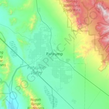
Nombre: Mapa topográfico Pahrump, altitud, relieve.

Lugar: Pahrump, Nye County, Nevada, United States (36.00121 -116.22802 36.40983 -115.89443)

Altitud media: 1,141 m

Altitud mínima: 641 m

Altitud máxima: 3,143 m

Summers in Pahrump are generally very hot and dry, with occasional pushes of monsoonal moisture beginning in early July. Being at a similar elevation to Las Vegas, daytime highs in summer average within a few degrees lower than that of Las Vegas. Record highs are similar between the two cities as well. A typical day during June through August brings temperatures around 100 °F (38 °C), and occasionally 110 °F (43 °C). Nighttime temperatures, however, are noticeably cooler. This is due to the lack of an urban heat island in Pahrump, allowing for intense radiative cooling after sundown. As a result, summer nights are pleasantly warm, bottoming out in the mid-60s or 70s °F (around 20 °C). Pahrump's location in a valley leads to large diurnal temperature ranges, typically 30 °F (17 °C) but occasionally 40 °F (22 °C). By late August and early September, the sweltering summer heat noticeably tempers down. September is the gateway to fall, which brings very pleasant weather. October highs are generally 80 °F (27 °C) and nighttime temperatures in the 50s °F (low teens °C). Due to its elevation, Pahrump is protected from the searing summer temperatures experienced in the nearby Death Valley.

Wikipedia (CC-BY-SA 3.0)

Otros mapas topográficos

Haga clic en un mapa para ver su topografía, su altitud y su relieve.

Tonopah

United States > Nevada > Nye County

Tonopah, Nye County, Nevada, United States

Altitud media: 1,842 m