
Haz una donación
Mapa topográfico Jammu y Cachemira
Haga clic en el mapa para ver la altitud.
Haz una donación
Acerca de este mapa
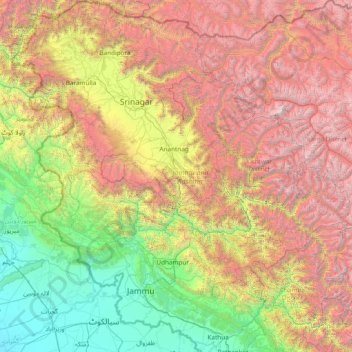
Nombre: Mapa topográfico Jammu y Cachemira, altitud, relieve.
Lugar: Jammu y Cachemira, India (32.27636 73.75003 34.78714 76.78032)
Altitud media: 2,430 m
Altitud mínima: 208 m
Altitud máxima: 7,015 m
Haz una donación
Otros mapas topográficos
Haga clic en un mapa para ver su topografía, su altitud y su relieve.
Surat
India > Guyarat > Katargam Taluka
La ciudad se sitúa en el margen izquierdo del río Tapi, a 22 km de su desembocadura. Si bien es una ciudad con puerto, este ha sido dañado por el río, por lo que se usa como tal el puerto de Hazira en el área metropolitana de Surat. Surate se localiza a latitud 21°10′12″ N y longitud 72°49′48″…
Altitud media: 13 m
Haz una donación
Avadi
India > Tamil Nadu > Poonamallee
Se encuentra a una altitud de 27 m.s.m. a 20 km de la capital estatal, Chennai, en la zona horaria UTC +5:30.
Altitud media: 23 m